

*****2019 marks 30 years since the Centennial Trail was established so we thought “We’re supposed to know all about hiking in the Black Hills. It’s probably about time that we hike this thing.” With that in mind, we needed to decide how we were going to do it. We could thru hike it in one long week to a week and a half hike, but we had other vacations planned this year and couldn’t get the time off from work. It was decided then that we would take the summer and section hike it on our weekends. It took us 2 1/2 months and a lot of driving to and from trailheads, but we got it done and I now know the Black Hills so much better than I ever did before.
Dakota Point to Brush Creek section.
I was going to do a recount of our hike, taking readers through each section, but that could get boring and besides we already have that in our Centennial Trail section of our website. So, I’m going to give my general thoughts, good and bad, and hopefully it will be a little more entertaining. If you want to learn more about our hike broken down section by section, click the link below.
I really enjoyed the trail, and I’ll get to that later, but first let me get my complaints out of the way.

Backpacking in Wind Cave section of the Centennial Trail.
If you do a google search for South Dakota’s Centennial Trail, the first thing that pops up is a PDF from the USDA Forest Service. This PDF gives you helpful information about the trail and includes a map with trail distances from trailhead to trailhead. Here’s my problem - the flier says that the trail is 111 miles long, so I started adding up the distances on the map expecting them to add up to 111 miles. No, they add up to 120 miles. Now, let’s get into the actual distances on the map. Some of them are pretty accurate, some of them are shorter than the map says, and there are some that are up to 3 miles longer than the map says. I didn’t have an expensive GPS device for tracking the trail. I just used my phone, but when the map says a section is 6.1 miles and it turns out to be 9.1, that’s wrong by 50%. So, the flyer says the trail is 111 miles long. The total miles of each section on the map adds up to 120. I’ve read accounts of it being 123, and my track ended up being 128. What is the actual length? - I would guess probably between the 123 to 125 range. I only bring this up because if someone is planning on thru hiking the trail, the trail could be 12 miles longer than they thought it was, which would mean another day of hiking. Like I said, the flyer gives a lot of useful information and we used it quite a bit for planning purposes, but they’ve probably been using the same one made 30 years ago and it might need to be updated.
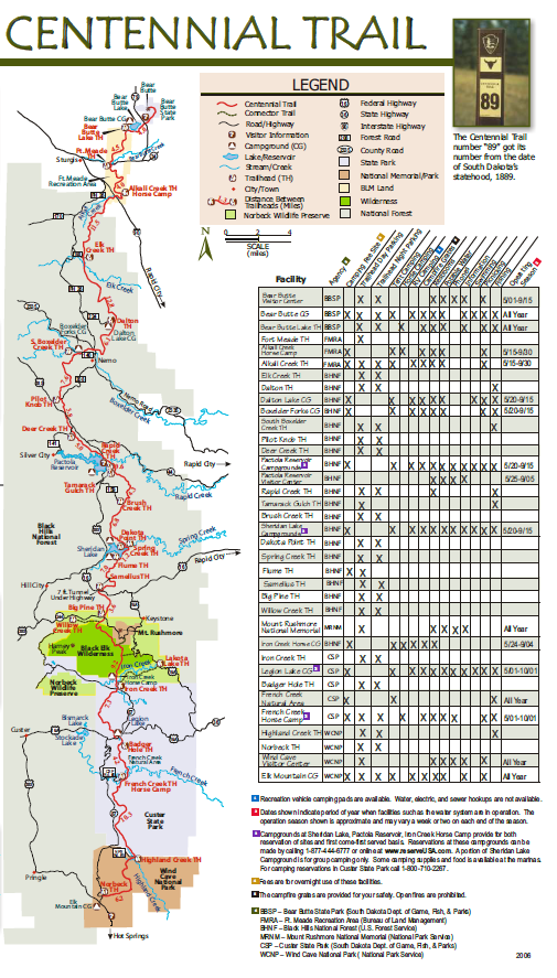
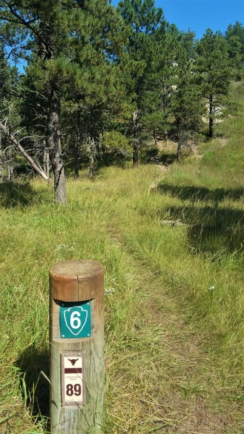
My next complaint are the trail markers. Throughout the trail there are no fewer than 5 different styles of trail markers. The best reasoning for why this is. is this; The first markers used on the trail were plastic posts with the trail number 89 on them. Throughout the years, a lot of these posts broke or were knocked down so small signs were nailed to trees (why there are 3 different versions of these, I don’t know). Also, the trail runs through Wind Cave National Park, Custer State park, and the Fort Meade Recreational Area, and these all have different ways of posting the trails that run within each park..

You see lots of signs like this knocked down by wind, time, cows, buffalo, etc.
One of the different signs for Wind Cave National Park.
All of this really isn’t a problem except with all the work that had to go into putting all the different signs up, you’d expect it to be a little better marked. You can be walking on a section of a trail where it’s very obvious where the trail is and then there will be 3 or 4 signs bunched together letting you know that yes, you are on the correct trail that you already knew you were on.
After that you will come to an intersection in the trail with no sign in sight or worse yet, one sign that is more confusing than it would be if it wasn’t there. You are left to look at your map and try to figure out which direction you need to go. That being said, we also came across one intersection that had 9 signs telling us which way to go.

Northern parts of the trail were marked very well - This crossing had 9 signs all in the same spot pointing to the correct route to take.
Another “Gotcha” that happens is, sometimes the trail will veer off of the trail you are on and you might not even realize you’ve lost the trail. This can lead to what I like to call CTSA. or Centennial Trail Sign Anxiety. The symptoms of CTSA are walking along the trail and suddenly realizing that you haven’t seen a sign for a while, so you start doubting yourself. If you’re hiking with a partner, “When’s the last time you saw a trail sign?” is a common question tossed back and forth.

Going north by Pactola, this section has no markers letting you know where the trail is, and it is not obvious by any means - overgrown and no trail.

On the way to Pactola Lake - where did the trail go? Looking for any signs to point the way. CTSA - “Anyone see a marker lately?”
That’s a lot of complaining about the trail signs, but in reality, there were only 2 instances when we got off trail and those were for a very short time and on the same section of trail (the first section in Custer State Park). For most of the northern section of the trail, I never even had to look at a map, so it’s not quite as bad as I make it out to be, just bring a map with you and follow a track on your phone and you should be fine.

We got lost trying to find the next section leading to the French Creek Wilderness area - the signs were not obvious once we hit the road and we had to do some searching. The signs were actually in the campground on the right side of the road.
Here’s my last complaint; The two sections from Pilot Knob to Dalton Lake were mainly ATV trails. I have no problems with people enjoying the hills on ATVs. They look like they’re having a blast and I would be too if I had one, but a hiking trail and an ATV trail should not be combined, especially when the hiking trail is suppose to be the premier hiking trail in the state and was established to celebrate the states’ centennial and to show off all the variety that the Black Hills have to offer. I understand that when the trail was being formed it probably was a very logical option to just use the trail that was already there and I also understand that if you’re hiking the trail during the middle of a week or after tourist season, that this might not be a problem, but when you’re constantly having to stand by the side of the trail while large groups of ATVs drive past or you’re constantly trying to navigate around the huge mud pits that these ATVs create, you start to question if you are really enjoying yourself and why are you doing it. There is no peace, there is no quiet, there’s only constant interruptions. Once again, I have no problem with the ATV riders and I’m not trying to take anything away from the ATV trails, but it would be nice if the Centennial Trail was rerouted to avoid these areas.

Saw hundreds of atvs and motorcycles on the 2 sections of the trail that were atv trails - Had to make a lot of pit stops to get out of the way of moving vehicles. Also hard to walk these trails when they are so muddy, rocky, and rutted.
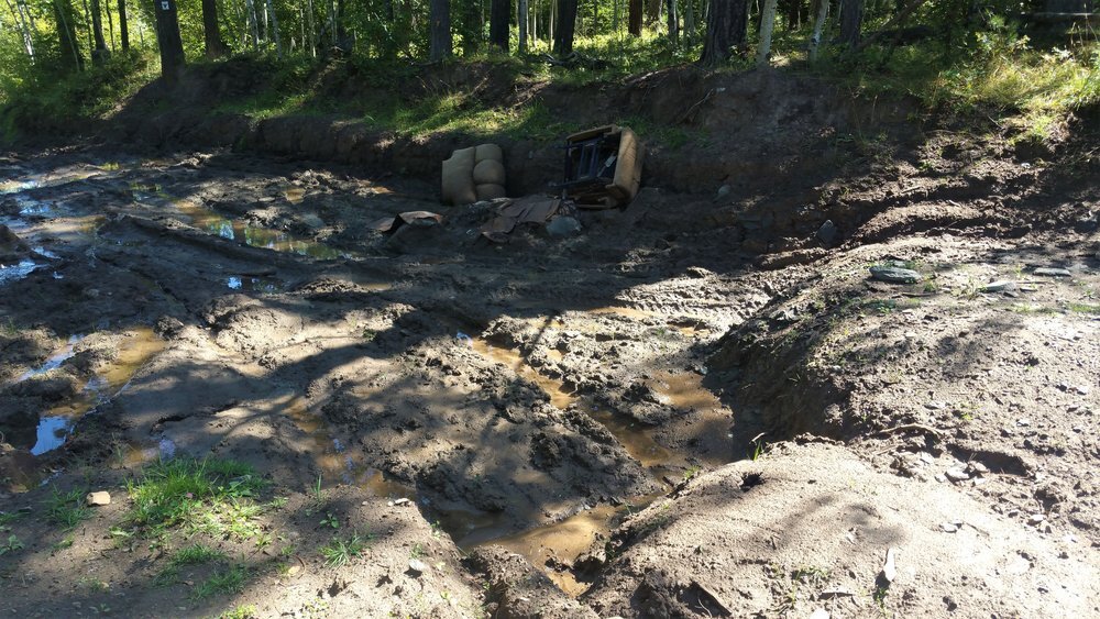
One of the many huge mud pits you had to walk through - yes that is a couch in the background.

Lots of rutted roads on the trail.
If you’re lucky enough to have read this far, you’re probably thinking that I really hated the trail but nothing could be farther from the truth. Let’s start with the wildlife. You tell me any other trail in the world where you’ll get this combination of wildlife. Here’s our list of animals we saw in order:
One rattlesnake in Wind Cave National Park. Luckily we only saw the one, but that was enough.

This rattlesnake was right on the trail in Wind Cave National Park. Could have been very bad.
Prairie dogs. We saw hundreds of prairie dogs. In Wind Cave National Park. You walk right through a huge prairie dog town.

Just one of the hundreds of prairie dogs we saw.
Buffalo/Bison in Wind Cave and Custer State Parks. From a herd in the valley below, to coming across a giant bull in the middle of the trail, these creatures of the prairie are truly impressive to see, and to see them from the trail and not from the protection of a car, can be exciting or terrifying, depending on the person.

This buffalo was right on the trail. Had to walk around him, but he never kept his eyes off of us.
Pronghorn Antelope in Wind Cave and Custer State Parks.

Saw a couple of these - just beautiful creatures.
Fox. I got a quick view of a Fox in Wind Cave National Park.
Elk. We were lucky enough to get a glimpse of an elk, appropriately as we were near Elk Creek .
Cows. Not necessarily “Wildlife” but in a state where there are more cows than people, it seems appropriate that you may have to navigate your way around some cows as you work your way through the grass prairies near Bear Butte Lake.

Numerous cows giving us the stare down.
Coyote. In a scene out of Dances with Wolves, as we were approaching Bear Butte Lake, we looked up on a bluff and saw a lone coyote watching us for a few seconds before it disappeared over the hill. Didn’t see any Jackrabbits though (you probably need to be from South Dakota to understand that lame attempt at humor).
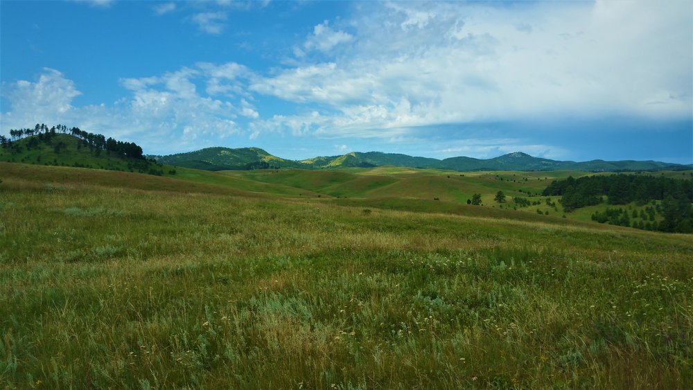
This trail is so uniquely South Dakota that it is the perfect trail to honor the state. Where else can you begin a trail working your way around buffalo and end it walking through herds of cows? Where else can you take a short side trip off the trail to visit one of the most iconic National Monuments in the country at Mount Rushmore and finish the trail on Bear Butte, one of the most sacred areas to the Native Americans that were the first to inhabited the hills?

Mount Rushmore.

Bear Butte
Where else can you see the beautiful mountain lakes of Pactola and Sheridan during the middle section of the trail and end the trail by passing by Bear Butte Lake which is in the beginning of the plains?

Sheridan Lake
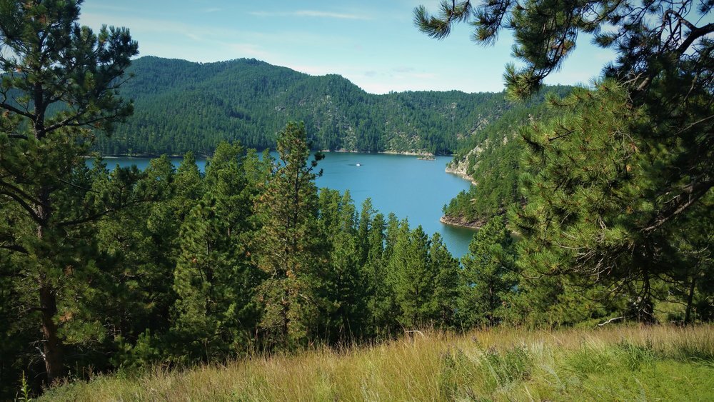
Pactola Lake

Bear Butte Lake
Where else can you see the majestic Cathedral Spires and look out over the hills from high atop a granite outcropping to looking out over the vast plains and being able to see for hundreds of miles as you near Bear Butte? All of this while being watched over by Black Elk Peak (formerly Harney Peak), which can be seen at various points for almost the entire length of the trail.

Can see the Cathedral Spires and Black Elk from this view.

Looking out over the plains approaching Bear Butte

Top of Bear Butte
There’s one more item I’d like to address and I’m not quite sure how I feel about it and that is the number of hikers on the trail. There were many sections of the trail where we didn’t see anyone. Some of the sections in Custer State Park had so little use that you could hardly see a trail. We saw more people on horseback than we did hiking. As far as backpackers go, we saw two men near Mt. Rushmore that were doing 30 miles or so, and then we saw two young men near Nemo that were going to thru hike from Dalton Lake to the southern terminus at Wind Cave. Part of me would really like to see more people out and enjoying this great trail, but then again the other part of me liked it all to myself so I could take in as much as possible.

Sunset in Wind Cave National Park - all alone for miles.
Here’s my final thoughts on the trail: We did it in a very wet year so water was abundant and there were wildflowers everywhere, although that did make for a couple of sketchy crossings of French Creek.

Wildflowers everywhere.


Had to cross French Creek twice. Was running pretty good and was pretty high.
If you are planning on thru hiking all or part of the trail, you’ll definitely want to check on creek conditions first because the hills can get hot and you could be going for long sections without any water sources. You’ll also want to keep an eye out on the weather. It can change fast. We got caught in a hail storm on the Brush Creek to Rapid Creek section where we ended up being pretty cold and wet.
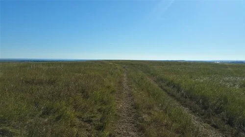
Hiking in the prairie near Bear Butte. Very hot and very dry.
If the thought of walking down the trail only to see a large buffalo sitting right in the middle of the trail scares you, you may want to reconsider hiking the Wind Cave and Custer State Park areas. Although there is no guarantee this will happen, you need to know it is a possibility. If it does happen, just give them plenty of space (100 yards if possible) and walk around them.

Two buffalo right on the trail - had to walk up the hill and around to avoid them.
Finally, keep an eye out for rattlesnakes and enjoy the trail.

Took 2 1/2 months of walking just on the weekends, but we made it. What a great time we had being together and seeing the beautiful country God has given us to enjoy. Love the Black Hills of South Dakota !!!!

• High opacity film that’s impossible to see through
• Fast and easy bubble-free application
• Durable vinyl
• 95µ density
Don't forget to clean the surface before applying the sticker.
This product is made especially for you as soon as you place an order, which is why it takes us a bit longer to deliver it to you. Making products on demand instead of in bulk helps reduce overproduction, so thank you for making thoughtful purchasing decisions!